Supercell Wx - free open source radar program

RandyDSok

Well-Known Member
Supercell Wx - free open source radar program

Quoting their main doc webpage...

"Supercell Wx is a free, open source application to visualize live and archive NEXRAD Level 2 and Level 3 data, and severe weather alerts. It displays continuously updating weather data on top of a responsive map, providing the capability to monitor weather events using reflectivity, velocity, and other products. Extended functionality, including weather reports and lightning data can be added using placefiles."

Like many radar apps and programs, I believe this is limited to use within the USA since they ( the government ) provide free direct access to the actual radar data on their NEXRAD radar sites. While not as mature as the GrLevel products, it provides a lot of similar features. This is available for both Linux and Windows OS. Supercell WX works with GrLevel compatible color pallettes and placefiles. The L3 radar uses super resolution products which are close to the resolution of the better L2 radar as well as can be downloaded quicker since they are pre-compiled data unlike L2 which is raw data and needs processed before you can view them. L2 products still are better if for no other reason than you can do additional processing beyond what is provided by the default L3 data. Supercell WX hasn't matured enough yet to provide any additional processing features, perhaps it may in the future.

This is a single radar site program and does not provide a national mosaic. You are able to view up to 4 panes of radar data in the one window.

More info and links to the downloads can be found on Supercell Wx — Supercell Wx documentation


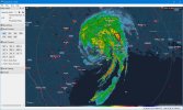
Here is a screenshot of the Houston radar while hurricane Beryl is passing through. I have setup my own custom color palettes and added a few placefiles as well.
Supercell_WX.jpg


As a sidenote... After Beryl made landfall, it produced over 100 tornado warnings ( unsure if that was in total or at one point in time ) with what is currently estimated of having 30 - 45 actual tornadoes touch down. The exact numbers of touchdowns are currently unknown and will take a considerable amount of time to verify precisely.
 

D.O.G.

Goblin 380 Supporter
Supercell Wx - free open source radar program

Quoting their main doc webpage...

"Supercell Wx is a free, open source application to visualize live and archive NEXRAD Level 2 and Level 3 data, and severe weather alerts. It displays continuously updating weather data on top of a responsive map, providing the capability to monitor weather events using reflectivity, velocity, and other products. Extended functionality, including weather reports and lightning data can be added using placefiles."

Like many radar apps and programs, I believe this is limited to use within the USA since they ( the government ) provide free direct access to the actual radar data on their NEXRAD radar sites. While not as mature as the GrLevel products, it provides a lot of similar features. This is available for both Linux and Windows OS. Supercell WX works with GrLevel compatible color pallettes and placefiles. The L3 radar uses super resolution products which are close to the resolution of the better L2 radar as well as can be downloaded quicker since they are pre-compiled data unlike L2 which is raw data and needs processed before you can view them. L2 products still are better if for no other reason than you can do additional processing beyond what is provided by the default L3 data. Supercell WX hasn't matured enough yet to provide any additional processing features, perhaps it may in the future.

This is a single radar site program and does not provide a national mosaic. You are able to view up to 4 panes of radar data in the one window.

More info and links to the downloads can be found on Supercell Wx — Supercell Wx documentation


Here is a screenshot of the Houston radar while hurricane Beryl is passing through. I have setup my own custom color palettes and added a few placefiles as well.

View attachment 25081


As a sidenote... After Beryl made landfall, it produced over 100 tornado warnings ( unsure if that was in total or at one point in time ) with what is currently estimated of having 30 - 45 actual tornadoes touch down. The exact numbers of touchdowns are currently unknown and will take a considerable amount of time to verify precisely.
Thanks for that 411 Randy. The wife is into all that stuff, and I passed it on to her. She's my cliff notes to world activities, lol
 

RandyDSok

Well-Known Member
Thanks for that 411 Randy. The wife is into all that stuff, and I passed it on to her. She's my cliff notes to world activities, lol

Ok then... how about some custom color tables ( attached ). These are what I made for myself to use. They use a common color theme across them except for the velocity ones. While each radar product represents different aspects, I liked having a similar color theme so when I switched to another product, I instinctively knew what the low to higher values looked like.

That isn't a typical setup for most radars although the base reflectivity is a set of commonly used colors often seen on radar reflectivity images. The exception being the velocity ones which are typically just red and green to represent the wind speeds moving to and away from a radar site. I also added additional colors beyond the red/green for more intense wind speeds.

The two BR color tables are for the reflectivity radar. This is the typical radar screen you will see on a radar picture. In the one I made, the darker colors and blacks are indictive of hail cores but to get higher values to show, I had to go to a lighter color and then blues etc since I was running out of colors to use. The colors used are shown across the bottom of the radar screen. I have two of these included, the one ending in "lo" are for use on dark backgrounds ( I have mine set to black or very dark so ) so the lighter precip doesn't show as much. While it varies, typically actual sprinkles will show up at the point that it starts to turn green on the color table.

There are two velocity color tables ( I don't think they have the second one working yet but I'm including it anyway ). Base Velocity and Storm Relative Velocity, the files names starting with BV and SRV, are for showing winds moving toward or away from the radar. Red colors indicate wind moving away from the radar with green colors representing wind moving toward the radar although the colors are subjective and can be made any color the person wants, this is just the typical standard set. I customized it so the slower winds are not as bright and then extended the colors used for much higher winds. With just straight winds coming in... it will make a S shaped sine wave in the colors with the radar site at the center. Tornadic and just circulating winds will converge making a bright red/green area that stands out. There are tons of example pics of what stronger tornadoes look like in this mode of radar. They also have a signature look in the reflectivity radar that there are also plenty of examples of on the internet often showing a hook in the signal. I think their SRV code is bugged or I didn't find it available, I think it's bugged and labeled as SRM on the screen buttons. I'm still providing the code since I assume that will be fixed at some point.

The Echo Tops color table ( filename starts with ET ) will show the height of the clouds in thousands of feet ( K feet ). Strong storms will tower high into the sky even if they are not going to produce a tornado.

One Hour Precipitation and Storm Total Precipitation ( OHP and STP files ) will give approximate rain totals for either the last hour or the total for the storm.

The final one I'm including is the Vertical Integrated Liquid ( VIL files ). This shows how much liquid is in any one column ( an area up and down in one spot ) of the storm. I seldom use it but included it anyway.

As mentioned, Supercell Wx is compatible with other GrLevel 2 and 3 color tables and placefiles. The online docs links to some but there are many others. Radar doesn't show all types of weather things like temps or lightning etc but this info can be added into it with the use of placefiles. Both color tables and placefiles are just text files and can be made by hand if you wish. You can make them with a plain text editor such as Notepad but not a word processor like Word since that uses a formatted text method not a plain text. Placefiles are usually automatically generated on servers for constantly changing information like temps... but static ones like place markers for locations can be made by hand if wanted.

When using the program, hold the shift button down on the keyboard and mouse over the area of interest to see what value it has. This lets you see the reflectivity values in BR mode, wind speeds in BV and SRV modes, rain amounts in OHP and STP, height in ET and amount of liquid in VIL etc.

You have an option for one of 3 types of maps... none if you don't sign up for any of the two offerings... and MapBox or MapTiler accounts for the others. I went with MapTiler since it doesn't require you to use a credit card when signing up for a free account. The Supercell Wx program lets you choose from several different map styles or a custom one that you make on the website of the one you signed up for. I made a custom one since I wanted an almost black background so I could see the radar data better. It is subjective on what you select as some people are the opposite of me and see it better on a light background... or prefer say a satellite image.
 

Attachments

  • Pal.zip
    4.3 KB · Views: 0

RandyDSok

Well-Known Member
While I typically use radar when I'm wanting to look at storms here or somewhere... that isn't all it is good for. Other scientists other than weathermen also use it to look at other things when storms are not around. We don't have any control over what the operational mode the radar is in, we can only select from the various products that are provided. There is an actual operator of each of the radar sites that select what mode the radar is operating in.

During times when no active storms are happening... they will often put the radar site into "clear air" mode. When in this mode, other things can be seen such as groups of bats, birds or insects as just a few that can be seen. In early mornings and the evenings, the birds and bats go into or leave their roosts. These show up as rings that expand or collapse depending on if they are coming or going. I've also seen insects swarming over the rivers in an area... I've even on occasion seen car and truck traffic moving on the highways. I've also seen the locations that wind turbine farms show up since the air gets disturbed by the big turbines moving.

The later, the cars and trucks on the roads showing up, only happen when an inversion happens which will bend the radar signal back towards the ground more than normal. It is very common when this inversion happens that you see what is called "radar bloom" and a lot of various types of different ground clutter shows up. I often see people asking about why they are seeing this stuff when it is perfectly clear skies outside. If you watch a national radar mosaic map of the nation... you'll often see these "blooms" grow from the east to the west in the evenings and then disappear the same in the morning times.

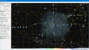
The following is a screenshot of tonight's radar bloom. In it, to the west of OKC in the center and up an down the west side of I-35 you can see several groups of wind turbine farms. Tonight, is a perfectly clear night and nothing but stars to see in the sky. I also see what I suspect are insect swarms in an area just east of OKC but on that, I'm guessing.

When in clear air mode, a single rotation of the radar can take a long time, ten minutes give or take depending on the exact mode. During active storms, the operators will speed up how fast the radar is read so they can see things quicker if needed. During really bad weather, they can take extra low level scans so they can update it in just minutes. It is common to also see the wind gust fronts moving in front of the line of storms. In fact, I think gust fronts are one of my favorite things to watch for some reason. Perhaps because it is typically just a line of high winds compressing the air and aren't actual clouds... we are just seeing an increase of the air density on the radar.

BasicRadar.jpg
 
Last edited:

RandyDSok

Well-Known Member
Thanks for that 411 Randy. The wife is into all that stuff, and I passed it on to her. She's my cliff notes to world activities, lol

I'm a little surprised that we didn't see Rob Lancaster pop in here and say anything. He had expressed some interest in having a radar program previously. I also had expected a post around July 4th from him, hope things are ok down his way.
 

RandyDSok

Well-Known Member
The attached file is a new color table I created for use with the base reflectivity ( BR ) radar which is the common radar screen you will see most of the time. In the previous zip file I included 2 BR color tables, one that I'll call normal that shows the lower dbz values more and a low one that has them more transparent so they don't show as much. This new one takes that to another level where values start going transparent at about 25 dbz and drop to fully transparent below 20 dbz.

The reasons I did this is because mist starts not much lower than around 18 dbz and actual rain doesn't start until the 30-35 dbz range. Higher dbz amounts indicate more of a radar return and hence stronger rain. FYI, hail will start showing around 56 dbz which is why I selected to have it the dark to black colors in the color table. Having the lower dbz transparent is better for times there are storms around and the lighter returns don't matter as much. You will still see some of the denser wind gust fronts show as well even when it isn't raining in those areas.

Basically, the low and now this very low BR color table will filter out these lower values so you can focus on more important storm related ones. This will also help filter out the "radar bloom" I mentioned but not completely get rid of it. That doesn't invalidate the other two tables since they can still be used if you want to see birds, bats, insects and other things when the weather permits.
 

Attachments

  • BR_Enh_v2_GrL3v2_vlo.zip
    604 bytes · Views: 1
Top Bottom